
Oxford Town Centre
The Oxford Town Centre dataset is a CCTV video of pedestrians in a busy downtown area in Oxford used for research and development of activity and face recognition systems. 1 Most recently Oxford Town Centre dataset has been used in studies for social distancing algorithms 4 and human sex classification. 3
The CCTV video was apparently obtained from a surveillance camera at the corner of Cornmarket and Market St. in Oxford, England and includes approximately 2,200 people. Since its publication in 2009 2 the Oxford Town Centre dataset has been used in over 60 verified research projects including commercial research by Amazon, Disney, OSRAM, and Huawei; and academic research in China, Israel, Russia, Singapore, the US, and Germany among dozens more.
The Oxford Town Centre dataset is unique in that it uses footage from a public surveillance camera that would otherwise be designated for public safety. Yet research citations show that the footage has been used in dozens of research projects with no connection to public safety, and that most of the research took place outside the UK. Pedestrians appearing in the video act normally and unrehearsed suggesting that the images were captured without consent.
- June 2020: The webpage for Oxford Town Centre has been taken down, and the dataset is apparently no longer being distributed.
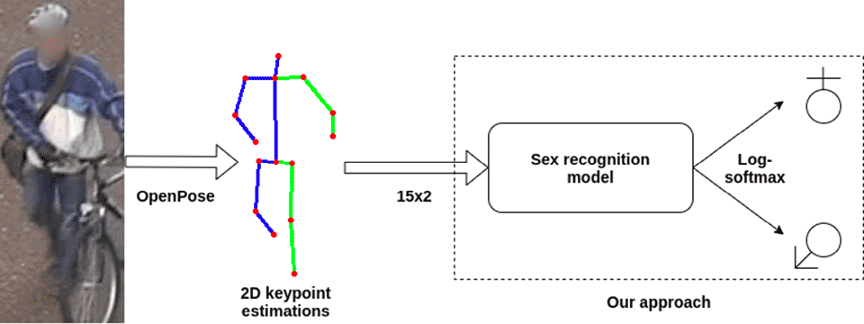
From Cornmarket to Sex Classification
A recently published 2020 research project from the University of Zagreb, Croatia has developed an algorithm using CCTV images from Cornmarket street in the Oxford Town Centre dataset to estimate biological sex with applications to surveillance and psychological analysis. The paper, "Can Human Sex Be Learned Using Only 2D Body Keypoint Estimations?", proposes a fully automated sexual classification system using only 2D keypoints. Their research is based on a larger image dataset called PETA, which comprises 10 subdatasets. For the subsets from 3DPes, SARC3D, and i-LID, the accuracy was relatively low, around 50%. However, on the Oxford Town Centre subset images the accuracy is very high, over 98%. 3 Overall, they claim an approximate 77% classification accuracy on all subsets, being "the first to use a deep learning approach for human sex recognition based only on 2D keypoint estimations."
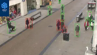
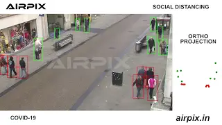
Social Distancing Algorithms
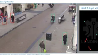
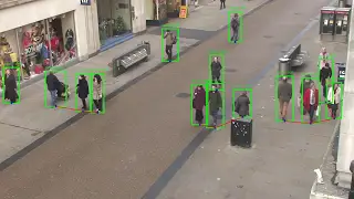
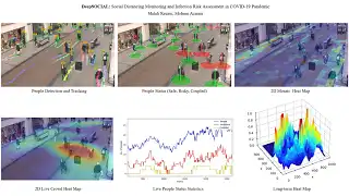
Another recent use of the original Oxford Town Centre CCTV dataset is for developing social distancing algorithms. In April 2020, the founder of Landing.ai tweeted that his company developed an AI tool to monitor employees and ensure social distancing in a workplace. His company posted a video to YouTube showing how the algorithm works using the Oxford Town Centre dataset in the promotional demo and in the development of the algorithm. Since Landing.ai posted about their AI tool, numerous other developers and companies used the same approach to create their own version. Searching for variations of Oxford Town Centre + social on YouTube yielded a handful of similar demos, including several by other commercial organizations including Airpix and JoltVision. Several examples of social distancing algorithm demos posted to YouTube are listed below beginning with the Landing.ai video first.

Information Supply Chain
To help understand how TownCentre has been used around the world by commercial, military, and academic organizations; existing publicly available research citing Oxford Town Centre was collected, verified, and geocoded to show how AI training data has proliferated around the world. Click on the markers to reveal research projects at that location.
- Academic
- Commercial
- Military / Government
Location
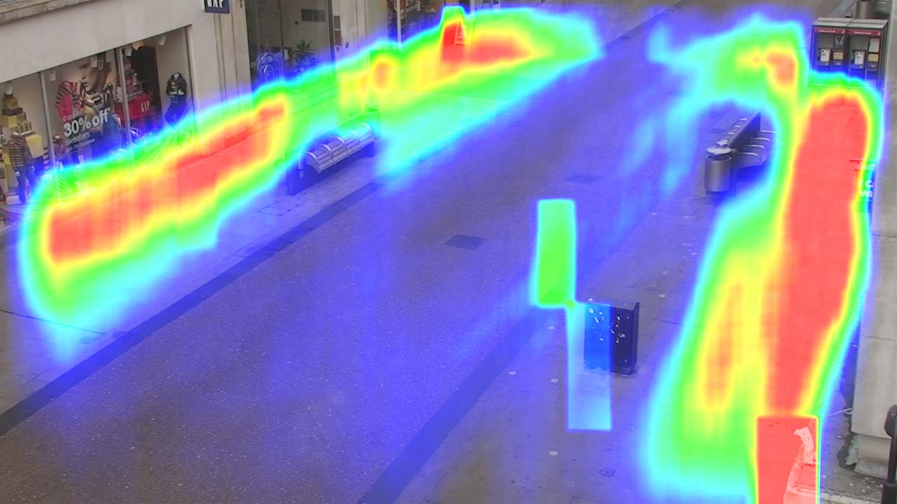
The street location of the camera used for the Oxford Town Centre dataset was confirmed by matching the road, benches, and store signs source. At that location, two public CCTV cameras exist mounted on the side of the Northgate House building at 13-20 Cornmarket St. The upper camera, apparently a public CCTV camera installed for security, is most likely the camera used to create this dataset.
The camera can be seen pointing in the same direction as the dataset's view in this public image, and the researchers used other existing public CCTV cameras for additional research projects increasing the likelihood that they could have had access to this camera.
The capture date is estimated to be during late November or early December in 2007 or 2008. The text on the storefront display shows a sale happening from December 2nd – 7th indicating the capture date was likely around this time. Prior to 2007 the Carphone Warehouse (photo, history) did not exist at this location. And since the sweaters in the GAP window display are more similar to those in a GAP website snapshot from November 2007, it was probably recorded in 2007. The slight waste residue near the bench and the lack street vendors that typically appear on a weekend, suggest that it was perhaps a weekday after rubbish removal.


Information Supply Chain
To help understand how TownCentre has been used around the world by commercial, military, and academic organizations; existing publicly available research citing Oxford Town Centre was collected, verified, and geocoded to show how AI training data has proliferated around the world. Click on the markers to reveal research projects at that location.
- Academic
- Commercial
- Military / Government
Citing This Work
If you reference or use any data from the Exposing.ai project, cite our original research as follows:
@online{Exposing.ai,
  author = {Harvey, Adam},
  title = {Exposing.ai},
  year = 2021,
  url = {https://exposing.ai},
  urldate = {2021-01-01}
}
If you reference or use any data from TownCentre cite the author's work:
@article{Benfold2011StableMT,
    author = "Benfold, Ben and Reid, I.",
    title = "Stable multi-target tracking in real-time surveillance video",
    journal = "CVPR 2011",
    year = "2011",
    pages = "3457-3464"
}
References
- 1 aBen Benfold, et al. "Stable multi-target tracking in real-time surveillance video". CVPR 2011. (2011): 3457-3464.
- 2 aBen Benfold, et al. "Guiding Visual Surveillance by Tracking Human Attention". (2009):
- 3 abKristijan Bartol, et al. "Can Human Sex Be Learned Using Only 2D Body Keypoint Estimations?". ArXiv abs/2011.03104. (2020):
- 4 aMaya Aghaei, et al. "Single Image Human Proxemics Estimation for Visual Social Distancing". ArXiv abs/2011.02018. (2020):